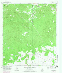
1970 Map of San Geronimo
USGS Topo · Published 1983About this map
San Geronimo appears in this 1970 survey during a period of transition, with its core settlement area noted as being under construction. Situated along the San Geronimo Creek, the landscape is defined by its ranching heritage and the critical importance of water in this part of Medina County. Extensive cattle operations are evident through the presence of the Gallagher Ranch and Kallison Ranch, supported by a network of specialized infrastructure including the River Windmill, Wildcat Windmill, and Moses Windmill.
Find a feature on this map
39 named features on this map. Tap any name to fly to it.
Don’t see what you’re looking for? This feature index may not catch every label — zoom into the map to look around manually.
Map Details
Editions of this 1970 San Geronimo Map
3 editions found
Other maps of this area

1953 · Culebra Hill
USGS Topo · 1:24,000

1953 · Helotes
USGS Topo · 1:24,000

1953 · Van Raub
USGS Topo · 1:24,000

1954 · San Antonio
USGS Topo · 1:250,000

1956 · Medina Lake
USGS Topo · 1:62,500

1957 · San Antonio
USGS Topo · 1:250,000

1958 · La Coste NE
USGS Topo · 1:24,000

1964 · Riomedina
USGS Topo · 1:24,000

1964 · Medina Lake
USGS Topo · 1:24,000
1966 · Culebra Hill
USGS Topo · 1:24,000