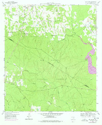
1959 Map of San Jacinto
USGS Topo · Published 1978About this map
Sam Houston National Forest dominates this landscape along the Walker and Montgomery County line, preserving a snapshot of the East Texas Piney Woods before the full impact of regional water management. While the forest canopy covers much of the terrain, the map reveals a persistent network of rural communities and family landmarks. Small settlements like San Jacinto and Bath are anchored by cultural hubs such as Ebenezer Ch, Farris Chapel, and Union Hill Ch. Educational and social history is visible in the location of the Little Zion Sch and several local burial grounds including Lee Cem.
Find a feature on this map
36 named features on this map. Tap any name to fly to it.
Don’t see what you’re looking for? This feature index may not catch every label — zoom into the map to look around manually.
Map Details
Editions of this 1959 San Jacinto Map
4 editions found
Other maps of this area

1954 · Beaumont
USGS Topo · 1:250,000

1957 · Beaumont
USGS Topo · 1:250,000

1958 · Lake Paula
USGS Topo · 1:24,000

1959 · Moore Grove
USGS Topo · 1:24,000

1959 · San Jacinto
USGS Topo · 1:24,000

1959 · Montgomery
USGS Topo · 1:24,000

1962 · Dacus
USGS Topo · 1:24,000

1962 · Richards
USGS Topo · 1:24,000

1962 · Galilee
USGS Topo · 1:24,000
1963 · Loma
USGS Topo · 1:24,000