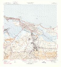
1947 Map of San Juan
USGS Topo · Published 1947About this map
La Fortaleza stands at the western tip of the islet of San Juan, anchoring a mid-century landscape where colonial history meets rapid urban expansion. This 1940s-era survey captures the capital city during a period of significant institutional growth, as evidenced by the extensive grounds of the Universidad de Puerto Rico and specialized facilities like the Hogar Insular de Niños and Sanatorio Insular.
Find a feature on this map
111 named features on this map. Tap any name to fly to it.
Don’t see what you’re looking for? This feature index may not catch every label — zoom into the map to look around manually.
Map Details
Editions of this 1947 San Juan Map
3 editions found
Other maps of this area

1940 · Carolina
USGS Topo · 1:30,000

1941 · Bayamon
USGS Topo · 1:30,000

1941 · San Juan
USGS Topo · 1:30,000

1941 · Carolina
USGS Topo · 1:30,000

1946 · Aguas Buenas
USGS Topo · 1:30,000

1946 · Naranjito
USGS Topo · 1:30,000

1946 · Gurabo
USGS Topo · 1:30,000

1947 · Carolina
USGS Topo · 1:30,000

1947 · Aguas Buenas NO
USGS Topo · 1:10,000

1947 · Bayamon
USGS Topo · 1:30,000