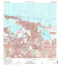
1969 Map of San Juan
USGS Topo · Published 1982About this map
The colonial fortifications of Sitio Historico Nacional and Fuerte San Cristobal anchor the northern coastline of San Juan, where the historic core gives way to rapid mid-century expansion. This 1960s survey records the dense urban density of San Juan Antiguo and the commercial corridors along Ave Ponce de Leon, while showing the suburban transition into Monacillo Urbano and Sabana Llana Sur.
Find a feature on this map
174 named features on this map. Tap any name to fly to it.
Don’t see what you’re looking for? This feature index may not catch every label — zoom into the map to look around manually.
Map Details
Editions of this 1969 San Juan Map
3 editions found
Other maps of this area

1940 · Carolina
USGS Topo · 1:30,000

1941 · Bayamon
USGS Topo · 1:30,000

1941 · San Juan
USGS Topo · 1:30,000

1941 · Carolina
USGS Topo · 1:30,000

1946 · Aguas Buenas
USGS Topo · 1:30,000

1946 · Naranjito
USGS Topo · 1:30,000

1946 · Gurabo
USGS Topo · 1:30,000

1947 · Carolina
USGS Topo · 1:30,000

1947 · Aguas Buenas NO
USGS Topo · 1:10,000

1947 · Bayamon
USGS Topo · 1:30,000