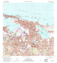
1969 Map of San Juan
USGS Topo · Published 1982About this map
San Juan and the surrounding metropolitan region appear in a state of significant expansion in this mid-century period. The densely built historic core on the peninsula, including the Cementerio Maria Magdalena, transitions into the burgeoning districts of Santurce, Miramar, and Condado. Industrial and infrastructural growth is evident along the Caño de San Antonio and near the Aeropuerto de Isla Grande. The map documents the rapid development of neighborhoods like Hato Rey Norte and Villa Palmeras, which are woven together by major arteries such as Avenida Ponce de Leon and Avenida Muñoz Rivera.
Find a feature on this map
160 named features on this map. Tap any name to fly to it.
Don’t see what you’re looking for? This feature index may not catch every label — zoom into the map to look around manually.
Map Details
Editions of this 1969 San Juan Map
3 editions found
Other maps of this area

1940 · Carolina
USGS Topo · 1:30,000

1941 · Bayamon
USGS Topo · 1:30,000

1941 · San Juan
USGS Topo · 1:30,000

1941 · Carolina
USGS Topo · 1:30,000

1946 · Aguas Buenas
USGS Topo · 1:30,000

1946 · Naranjito
USGS Topo · 1:30,000

1946 · Gurabo
USGS Topo · 1:30,000

1947 · Carolina
USGS Topo · 1:30,000

1947 · Aguas Buenas NO
USGS Topo · 1:10,000

1947 · Bayamon
USGS Topo · 1:30,000