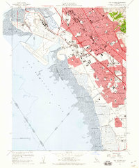
1959 Map of San Leandro
USGS Topo · Published 1960About this map
Metropolitan Oakland International Airport dominates the shoreline of the East Bay in the late 1950s, a period defined by the rapid suburbanization of southern Oakland and San Leandro. The Nimitz Freeway serves as a primary artery, cutting through dense residential grids populated by dozens of local institutions like Washington School and Bancroft Jr High Sch. Near the mudflats of San Francisco Bay, industrial and aviation footprints expand, seen in the proximity of the Oakland Naval Air Station to emerging neighborhoods like Mulford Gardens. Further south, the community of Russell City remains distinct, while the hills are anchored by the Knowland State Arboretum and Park and Lake Chabot. This survey documents a landscape in transition from its historic waterfront landings, such as Roberts Landing, toward a modern era of high-speed transit and extensive municipal development.
Find a feature on this map
89 named features on this map. Tap any name to fly to it.
Don’t see what you’re looking for? This feature index may not catch every label — zoom into the map to look around manually.
Map Details
Editions of this 1959 San Leandro Map
4 editions found
Other maps of this area

1892 · San Mateo
USGS Topo · 1:62,500

1895 · San Francisco
USGS Topo · 1:62,500

1896 · San Mateo
USGS Topo · 1:62,500

1897 · Concord
USGS Topo · 1:62,500

1899 · San Francisco
USGS Topo · 1:62,500

1899 · Haywards
USGS Topo · 1:62,500

1899 · San Mateo
USGS Topo · 1:62,500

1915 · San Mateo
USGS Topo · 1:62,500

1915 · Haywards
USGS Topo · 1:62,500

1915 · Concord
USGS Topo · 1:62,500