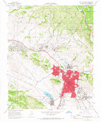
1965 Map of San Luis Obispo
USGS Topo · Published 1967About this map
San Luis Obispo serves as the focal point of this mid-1960s study, showcasing a city in transition where historical landmarks like the Old Mission and the San Luis Obispo de Tolosa (Adobe) sit adjacent to expanding mid-century infrastructure. The map details the significant footprint of California State Polytechnic College and the specialized facilities at the California Mens Colony, including both the West Facility and East Facility. To the north and west, the landscape is defined by the Los Padres National Forest and the Camp San Luis Obispo Military Res, while the Southern Pacific railroad snakes through the hills toward Cuesta Pass. This period shows the early development of modern residential neighborhoods and shopping centers around Laguna Lake, while numerous mining operations such as the La Trinidad Mine and Pick and Shovel Mine persist in the surrounding rugged terrain of the Prefumo Hills.
Find a feature on this map
97 named features on this map. Tap any name to fly to it.
Don’t see what you’re looking for? This feature index may not catch every label — zoom into the map to look around manually.
Map Details
Editions of this 1965 San Luis Obispo Map
5 editions found

Other maps of this area

1897 · Port Harford
USGS Topo · 1:62,500

1897 · San Luis Obispo
USGS Topo · 1:62,500

1897 · Cayucos
USGS Topo · 1:62,500

1897 · Arroyo Grande
USGS Topo · 1:62,500

1900 · San Luis
USGS Topo · 1:125,000

1937 · Cayucos
USGS Topo · 1:62,500

1941 · Port San Luis
USGS Topo · 1:62,500

1942 · San Luis Obispo
USGS Topo · 1:62,500

1942 · Arroyo Grande
USGS Topo · 1:62,500

1943 · Cayucos
USGS Topo · 1:62,500