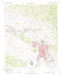
1965 Map of San Luis Obispo
USGS Topo · Published 1975About this map
The historic heart of San Luis Obispo is anchored by the Mission San Luis Obispo de Tolosa and the surrounding Adobe structures, illustrating the city's transition from a mission outpost to a bustling regional center. By the mid-1960s, the landscape reflects significant institutional growth, featuring the sprawling California State Polytechnic College and its dedicated airport. To the northwest, the California Mens Colony and Camp San Luis Obispo Military Reservation occupy the valley floor between the Cuesta Ridge and the Irish Hills. This era shows the community's dependence on the Southern Pacific railroad, which threads through Cuesta Pass and serves the industrial and residential corridors of the city. Numerous local schools like Teach Sch and Quintana Sch, alongside the Sierra Vista Hosp, mark the suburban expansion nearing Laguna Lake and the foothills of Bishop Peak.
Find a feature on this map
72 named features on this map. Tap any name to fly to it.
Don’t see what you’re looking for? This feature index may not catch every label — zoom into the map to look around manually.
Map Details
Editions of this 1965 San Luis Obispo Map
5 editions found

Other maps of this area

1897 · Port Harford
USGS Topo · 1:62,500

1897 · San Luis Obispo
USGS Topo · 1:62,500

1897 · Cayucos
USGS Topo · 1:62,500

1897 · Arroyo Grande
USGS Topo · 1:62,500

1900 · San Luis
USGS Topo · 1:125,000

1937 · Cayucos
USGS Topo · 1:62,500

1941 · Port San Luis
USGS Topo · 1:62,500

1942 · San Luis Obispo
USGS Topo · 1:62,500

1942 · Arroyo Grande
USGS Topo · 1:62,500

1943 · Cayucos
USGS Topo · 1:62,500