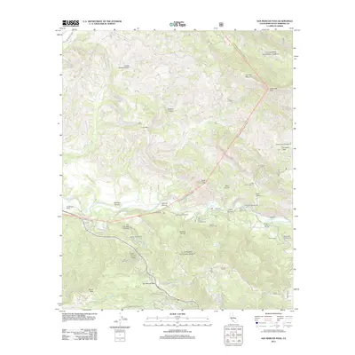
2012 Map of San Marcos Pass
USGS Topo · Published 2012About this map
The Santa Ynez River carves a central path through this Santa Barbara County landscape, creating a corridor of activity and recreation. Along its banks, a concentration of public sites like Los Prietos Campground, Fremont Campground, and the Los Prietos Boys Camp reflect the area's role as a regional retreat. The terrain is defined by dramatic elevation changes, rising from the river valley toward landmarks like Alexander Peak and Old Man Mountain, while San Marcos Pass serves as the primary transit point through the mountains.
Find a feature on this map
53 named features on this map. Tap any name to fly to it.
Don’t see what you’re looking for? This feature index may not catch every label — zoom into the map to look around manually.
Map Details
Editions of this 2012 San Marcos Pass Map
This is the sole edition of this map. No revisions or reprints were ever made.
Other maps of this area

1902 · Santa Ynez
USGS Topo · 1:125,000

1905 · Santa Ynez
USGS Topo · 1:125,000

1941 · San Rafael Mtn.
USGS Topo · 1:62,500

1942 · Goleta
USGS Topo · 1:62,500

1942 · San Rafael Mtn.
USGS Topo · 1:62,500

1942 · Little Pine Mountain
USGS Topo · 1:24,000

1943 · Big Pine Mountain
USGS Topo · 1:31,680

1943 · San Rafael Mtn.
USGS Topo · 1:62,500

1944 · Santa Barbara
USGS Topo · 1:31,680
1944 · Big Pine Mtn
USGS Topo · 1:31,680