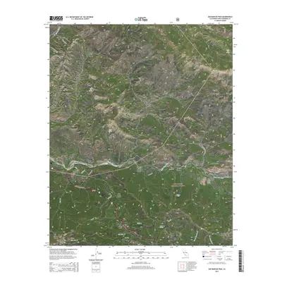
2015 Map of San Marcos Pass
USGS Topo · Published 2015About this map
San Marcos Pass and the surrounding Santa Ynez Mountains define this high-elevation landscape within the Los Padres National Forest. The 2015 survey details the steep drainage networks of Horse Canyon and Redrock Canyon as they descend toward the Santa Ynez River. The presence of Stagecoach Rd and San Marcos Pass Rd highlights the long-standing transportation corridor between the coast and the inland valley. Water sources are critical markers in this arid terrain, including Wellhouse Falls, Laurel Springs, and Loma Alta Spring. Along the river, localized features like Nineteen Oaks and Arroyo Burro provide reference points for land use and remote settlement patterns. Notable peaks such as Brush Peak and Old Man Mtn anchor the topography, reflecting the dramatic relief and geological character of this part of Santa Barbara County.
Find a feature on this map
47 named features on this map. Tap any name to fly to it.
Don’t see what you’re looking for? This feature index may not catch every label — zoom into the map to look around manually.
Map Details
Editions of this 2015 San Marcos Pass Map
This is the sole edition of this map. No revisions or reprints were ever made.
Other maps of this area

1902 · Santa Ynez
USGS Topo · 1:125,000

1905 · Santa Ynez
USGS Topo · 1:125,000

1941 · San Rafael Mtn.
USGS Topo · 1:62,500

1942 · Goleta
USGS Topo · 1:62,500

1942 · San Rafael Mtn.
USGS Topo · 1:62,500

1942 · Little Pine Mountain
USGS Topo · 1:24,000

1943 · Big Pine Mountain
USGS Topo · 1:31,680

1943 · San Rafael Mtn.
USGS Topo · 1:62,500

1944 · Santa Barbara
USGS Topo · 1:31,680
1944 · Big Pine Mtn
USGS Topo · 1:31,680