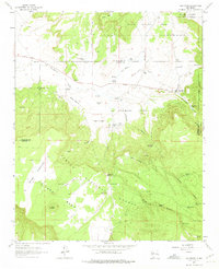
1963 Map of San Mateo
USGS Topo · Published 1975About this map
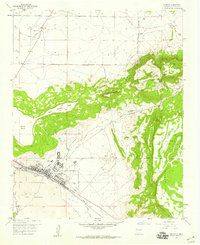
San Mateo serves as the focal point for this mid-century survey of the high desert and mesas at the foot of the San Mateo Mountains. The settlement's agricultural and ranching roots are evident in the complex network of water features, including San Mateo Reservoir, San Mateo Creek, and numerous stock tanks like Youngs Tank and Mule Tank. The presence of the San Mateo Mine and scattered Prospects to the northwest indicate the era's mining activity, while an abandoned CCC Camp on the Grant Boundary marks the legacy of earlier federal land projects.
Find a feature on this map
48 named features on this map. Tap any name to fly to it.
Don’t see what you’re looking for? This feature index may not catch every label — zoom into the map to look around manually.
Map Details
Editions of this 1963 San Mateo Map
4 editions found
Other maps of this area

1883 · Mt. Taylor
USGS Topo · 1:250,000

1886 · Mt. Taylor
USGS Topo · 1:250,000

1892 · Mt. Taylor
USGS Topo · 1:250,000

1899 · Mt. Taylor
USGS Topo · 1:250,000

1957 · Lobo Springs
USGS Topo · 1:24,000

1957 · Ambrosia Lake
USGS Topo · 1:24,000

1957 · Mount Taylor
USGS Topo · 1:24,000

1957 · Dos Lomas
USGS Topo · 1:24,000
1957 · Grants
USGS Topo · 1:24,000

1958 · Albuquerque
USGS Topo · 1:250,000