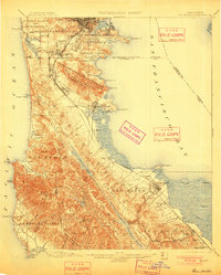
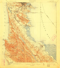
1899 Map of San Mateo
USGS Topo · Published 1901About this map
The Southern Pacific R.R. corridor dictates the industrial and residential growth of the Peninsula in the late nineteenth century, linking the emerging South San Francisco with the established town of San Mateo. The map illustrates a landscape in transition, where large land grants like Corral de Tierra (Palomares) and Pulgas meet the burgeoning rail-side developments of Burlingame and Baden Sta. Institutional presence is notable at the San Mateo Co. Alms House and the Industrial School near the San Francisco city line.
Find a feature on this map
98 named features on this map. Tap any name to fly to it.
Don’t see what you’re looking for? This feature index may not catch every label — zoom into the map to look around manually.
Map Details
Editions of this 1899 San Mateo Map
6 editions found
Other maps of this area

1892 · San Mateo
USGS Topo · 1:62,500

1895 · San Francisco
USGS Topo · 1:62,500

1896 · San Mateo
USGS Topo · 1:62,500

1897 · Concord
USGS Topo · 1:62,500

1897 · Palo Alto
USGS Topo · 1:62,500

1897 · Tamalpais
USGS Topo · 1:62,500

1899 · San Francisco
USGS Topo · 1:62,500

1899 · Palo Alto
USGS Topo · 1:62,500

1899 · Haywards
USGS Topo · 1:62,500

1899 · San Mateo
USGS Topo · 1:62,500