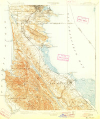
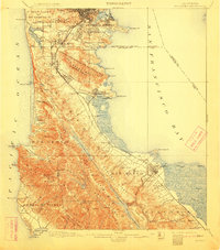
1899 Map of San Mateo
USGS Topo · Published 1905About this map
The Southern Pacific R. R. serves as the primary artery for the San Francisco Peninsula in the 1890s, connecting a series of growing communities along the western shore of San Francisco Bay. In the north, the Pueblo Lands of San Francisco meet the extensive cluster of Cemeteries at Colma, while the interior landscape is defined by the high ridges of Sweeny Ridge and Buri Buri Ridge. This era shows a Peninsula transitioning into a vital residential and industrial corridor, evidenced by the infrastructure of Crystal Springs Lake and the Crystal Springs Dam. Local social history is grounded in the presence of the San Mateo Co. Alms House and several early educational institutions including Hoyt School and Reid School. From the coastal wetlands of Laguna de la Merced to the developing town sites of San Carlos and Millbrae, the survey provides a detailed look at the peninsula's geography before the suburban expansion of the mid-20th century.
Find a feature on this map
95 named features on this map. Tap any name to fly to it.
Don’t see what you’re looking for? This feature index may not catch every label — zoom into the map to look around manually.
Map Details
Editions of this 1899 San Mateo Map
6 editions found
Other maps of this area

1892 · San Mateo
USGS Topo · 1:62,500

1895 · San Francisco
USGS Topo · 1:62,500

1896 · San Mateo
USGS Topo · 1:62,500

1897 · Concord
USGS Topo · 1:62,500

1897 · Palo Alto
USGS Topo · 1:62,500

1897 · Tamalpais
USGS Topo · 1:62,500

1899 · San Francisco
USGS Topo · 1:62,500

1899 · Palo Alto
USGS Topo · 1:62,500

1899 · Haywards
USGS Topo · 1:62,500

1899 · San Mateo
USGS Topo · 1:62,500