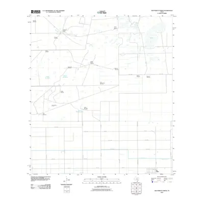
2010 Map of San Perlita North
USGS Topo · Published 2010About this map
San Perlita sits at the southern edge of this coastal prairie landscape, where the agricultural grid meets a vast network of water management and cattle-ranching infrastructure. The terrain is defined by numerous earthen tanks and ponds, including Tanque del Burro and Tajitos, which supported the livestock operations of historic properties like Punta del Monte Ranch. Windmills are the dominant cultural feature across the northern half of the quadrangle, with named markers such as the Repardo Windmill, Cabeza Blanca Windmill, and Fourth of July Windmill providing essential water sources for the cattle industry. The introduction of industrial extraction is evident at the Raymondville Oil Field in the west, while the massive East Main Drain and regular road grid including Bush Rd and FM 2209 illustrate the extensive mid-century engineering used to transform the Willacy County brush country into productive ranch and farmland.
Find a feature on this map
37 named features on this map. Tap any name to fly to it.
Don’t see what you’re looking for? This feature index may not catch every label — zoom into the map to look around manually.
Map Details
Editions of this 2010 San Perlita North Map
This is the sole edition of this map. No revisions or reprints were ever made.
Other maps of this area

1921 · Tarida Ranch
USGS Topo · 1:62,500

1922 · La Sal Vieja
USGS Topo · 1:62,500

1953 · Brownsville
USGS Topo · 1:250,000

1956 · Rudolph
USGS Topo · 1:24,000

1956 · San Perlita South
USGS Topo · 1:24,000

1956 · Rosita Lake
USGS Topo · 1:24,000

1956 · San Perlita North
USGS Topo · 1:24,000
1956 · Rosita Lake NE
USGS Topo · 1:24,000
1956 · Willamar
USGS Topo · 1:24,000

1956 · Yturria
USGS Topo · 1:24,000