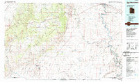
1986 Map of San Rafael Desert
USGS Topo · Published 1987About this map
San Rafael Reef forms the dramatic eastern boundary of the San Rafael Swell, a massive geological uplift that dominates the western half of this mid-1980s landscape. To the east, the Green River carves a winding path through the high desert, creating distinctive features like the sharp meander of Bowknot Bend and the depths of Labyrinth Canyon. The map reveals a transition from traditional livestock grazing lands like The Pasture and Keesle Country to modern aerospace use, most notably with the Utah Launch Complex and a portion of the White Sands Missile Range near the town of Green River. Human presence is sparse, centered around points like The Frenchmans and the recreational lands at Goblin Valley State Reserve. Transport is defined by the Denver and Rio Grande Western railroad and the corridor of Interstate 70, providing a stark contrast to the labyrinthine drainage systems of Iron Wash and Temple Wash.
Find a feature on this map
72 named features on this map. Tap any name to fly to it.
Don’t see what you’re looking for? This feature index may not catch every label — zoom into the map to look around manually.
Map Details
Editions of this 1986 San Rafael Desert Map
2 editions found
Other maps of this area

1885 · San Rafael
USGS Topo · 1:250,000

1885 · Manti
USGS Topo · 1:250,000

1885 · East Tavaputs
USGS Topo · 1:250,000

1885 · La Sal
USGS Topo · 1:250,000

1885 · Fish Lake
USGS Topo · 1:250,000

1886 · Price River
USGS Topo · 1:250,000

1895 · Manti
USGS Topo · 1:250,000

1896 · Price River
USGS Topo · 1:250,000

1896 · Fish Lake
USGS Topo · 1:250,000

1923 · Castle Dale
USGS Topo · 1:62,500