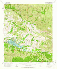
1959 Map of San Rafael Mtn
USGS Topo · Published 1963About this map
The San Rafael Mountains dominate this 1959 landscape, where the recently completed Cachuma Dam has transformed the valley into Cachuma Lake. This era marks a significant shift in the region's geography, as the U.S. Bureau of Reclamation's water project created a central recreational hub near Cachuma Village. The map reveals a complex network of backcountry camps such as Manzana Narrows Camp and Mission Pine Camp, alongside legacy landholdings like Rancho San Fernando Rey and San Marcos Ranch.
Find a feature on this map
99 named features on this map. Tap any name to fly to it.
Don’t see what you’re looking for? This feature index may not catch every label — zoom into the map to look around manually.
Map Details
Editions of this 1959 San Rafael Mtn Map
2 editions found
Other maps of this area

1902 · Santa Ynez
USGS Topo · 1:125,000

1905 · Santa Ynez
USGS Topo · 1:125,000

1905 · Lompoc
USGS Topo · 1:125,000

1941 · San Rafael Mtn.
USGS Topo · 1:62,500

1941 · McPherson Peak
USGS Topo · 1:62,500

1942 · Lompoc
USGS Topo · 1:125,000

1942 · Gaviota
USGS Topo · 1:62,500

1942 · Goleta
USGS Topo · 1:62,500

1942 · San Rafael Mtn.
USGS Topo · 1:62,500

1942 · Tepusquet Peak
USGS Topo · 1:62,500