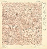
1950 Map of San Sebastian SO
USGS Topo · Published 1950About this map
The Río Grande de Anasco cuts a deep, winding path through the mountainous terrain of western Puerto Rico, defining the jurisdictional boundary between the Municipio de San Sebastian and the Municipio de Las Marias. This mid-century topographical study reveals a landscape dominated by traditional coffee-growing districts, or barrios, including Maravilla Norte, Maravilla Sur, and Mirabales. The concentration of structures at Las Marias and the presence of the Hacienda Buena Vista suggest the importance of the agricultural economy to the local settlement pattern. Steep slopes are drained by a complex network of streams such as Quebrada Moralon and Quebrada Grande, while smaller centers like Perchas and Purísima Concepción are linked by a system of roads and trails that follow the natural contours of the Cordillera Central.
Find a feature on this map
21 named features on this map. Tap any name to fly to it.
Don’t see what you’re looking for? This feature index may not catch every label — zoom into the map to look around manually.
Map Details
Editions of this 1950 San Sebastian SO Map
This is the sole edition of this map. No revisions or reprints were ever made.
Other maps of this area

1938 · Alto Sano
USGS Topo · 1:20,000

1938 · San Sebastian
USGS Topo · 1:20,000

1941 · San Sebastian
USGS Topo · 1:30,000

1941 · Rosario
USGS Topo · 1:30,000

1942 · Central La Plata
USGS Topo · 1:30,000

1942 · Rosario
USGS Topo · 1:30,000

1946 · Maricao
USGS Topo · 1:30,000

1946 · Ciales
USGS Topo · 1:30,000
1947 · Maricao NO
USGS Topo · 1:10,000
1947 · Maricao NE
USGS Topo · 1:10,000
Featured Places
- Las Marías, Las Marías
- Sector Quinto Ríos, San Sebastián
- Sector Lulo Rivera, San Sebastián
- Juncal, San Sebastián
- Maravilla Este, Las Marías