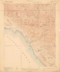
1919 Map of San Simeon
USGS Topo · Published 1919About this map
Hearst Ranch and the coastal village of San Simeon anchor this 1919 study of the Central California coast, where the Pacific Ocean meets the steep slopes of the Santa Lucia Range. The landscape is defined by a series of narrow canyons and arroyos, including Arroyo de la Cruz and Santa Rosa Creek, which supported early ranching and small-scale settlements. To the south, the town of Cambria serves as a hub near Leffingwell Landing.
Find a feature on this map
75 named features on this map. Tap any name to fly to it.
Don’t see what you’re looking for? This feature index may not catch every label — zoom into the map to look around manually.
Map Details
Editions of this 1919 San Simeon Map
4 editions found
Other maps of this area

1897 · Cayucos
USGS Topo · 1:62,500

1900 · San Luis
USGS Topo · 1:125,000

1919 · Bryson
USGS Topo · 1:62,500

1919 · Bradley
USGS Topo · 1:62,500

1919 · Adelaida
USGS Topo · 1:62,500

1919 · Piedras Blancas
USGS Topo · 1:62,500

1919 · San Simeon
USGS Topo · 1:62,500

1921 · Cape San Martin
USGS Topo · 1:62,500

1927 · Piedras Blancas
USGS Topo · 1:62,500

1932 · Adelaida
USGS Topo · 1:62,500