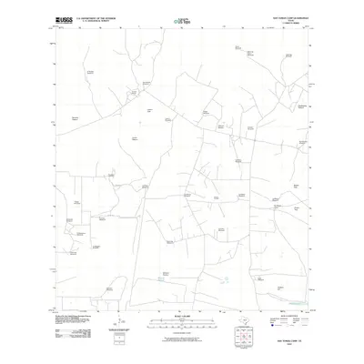
2010 Map of San Tomas Camp
USGS Topo · Published 2010About this map
Encino Ranch and the eponymous San Tomas Camp anchor this landscape in Brooks County, where the southern Texas brush country is defined by ranching infrastructure and petroleum extraction. The map reveals a sophisticated network of water and land management, documented through numerous named windmills and divided tracts like Remuda Pasture, Lucero Trap, and Mineral Pasture. These labels point to a long-standing history of livestock grazing in an arid environment where water sources like the Trieste Windmill and Leoncita Windmill were essential for survival and industry. Near the center of the sheet, the Viboras Oil Field signifies the region's energy development, while the El Lucero Cemetery on Lucero St provides a point of interest for genealogists tracing family roots in this corner of the Rio Grande Plain. Natural features such as Quiteria Lake and Quiteria Hill provide the few topographic breaks in the terrain.
Find a feature on this map
39 named features on this map. Tap any name to fly to it.
Don’t see what you’re looking for? This feature index may not catch every label — zoom into the map to look around manually.
Map Details
Editions of this 2010 San Tomas Camp Map
This is the sole edition of this map. No revisions or reprints were ever made.
Other maps of this area

1921 · Falfurrias
USGS Topo · 1:125,000

1923 · Armstrong
USGS Topo · 1:62,500

1928 · Sarita
USGS Topo · 1:125,000

1949 · Mc Allen
USGS Topo · 1:250,000

1950 · Corpus Christi
USGS Topo · 1:250,000

1953 · Brownsville
USGS Topo · 1:250,000

1954 · McAllen
USGS Topo · 1:250,000

1954 · Sarita
USGS Topo · 1:62,500

1956 · Corpus Christi
USGS Topo · 1:250,000

1956 · Pita Camp
USGS Topo · 1:24,000