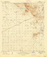
1943 Map of San Xavier Mission
USGS Topo · Published 1947About this map
The San Xavier del Bac Mission anchors the eastern edge of this landscape, standing near the banks of the Santa Cruz River in the broad Santa Cruz Valley. Surveyed during the early 1940s, the map documents a transition from the rugged volcanic peaks of the Tucson Mountains to the flat alluvial plains of the Papago Indian Reservation and San Xavier Indian Reservation. Notable social and scientific landmarks of the era are clustered near the northeast corner, including the Desert Laboratory on Tumamoc Hill, St Marys Hospital, and the Pima County Preventorium. Transportation is defined by the Ajo-Tucson Highway cutting diagonally across the basin, while scattered outposts like Triple C Ranch and Robles Well reflect the era's reliance on isolated water sources and ranching tenures in the arid desert terrain.
Find a feature on this map
34 named features on this map. Tap any name to fly to it.
Don’t see what you’re looking for? This feature index may not catch every label — zoom into the map to look around manually.
Map Details
Editions of this 1943 San Xavier Mission Map
3 editions found

Other maps of this area

1904 · Patagonia
USGS Topo · 1:125,000

1904 · Tucson
USGS Topo · 1:125,000

1905 · Patagonia
USGS Topo · 1:125,000

1905 · Tucson
USGS Topo · 1:125,000

1920 · Arivaca
USGS Topo · 1:125,000

1925 · Samaniego Peak
USGS Topo · 1:62,500

1925 · San Xavier
USGS Topo · 1:62,500

1926 · Helvetia
USGS Topo · 1:62,500

1934 · Tucson Mountains
USGS Topo · 1:125,000

1939 · Twin Buttes
USGS Topo · 1:62,500