
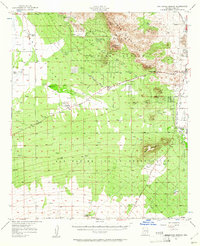
1957 Map of San Xavier Mission
USGS Topo · Published 1958About this map
San Xavier del Bac Mission stands as a focal point in this desert landscape, situated along the West Branch Santa Cruz River. The map details a period of transition for Pima County, showing the intersection of traditional land use and burgeoning cultural attractions. To the north, the Tucson Mountains house the Arizona-Sonora Desert Museum and the cinematic Old Tucson replica, reflecting the region's mid-century identity.
Find a feature on this map
47 named features on this map. Tap any name to fly to it.
Don’t see what you’re looking for? This feature index may not catch every label — zoom into the map to look around manually.
Map Details
Editions of this 1957 San Xavier Mission Map
2 editions found
Other maps of this area

1904 · Patagonia
USGS Topo · 1:125,000

1904 · Tucson
USGS Topo · 1:125,000

1905 · Patagonia
USGS Topo · 1:125,000

1905 · Tucson
USGS Topo · 1:125,000

1920 · Arivaca
USGS Topo · 1:125,000

1925 · Samaniego Peak
USGS Topo · 1:62,500

1925 · San Xavier
USGS Topo · 1:62,500

1926 · Helvetia
USGS Topo · 1:62,500

1934 · Tucson Mountains
USGS Topo · 1:125,000

1939 · Twin Buttes
USGS Topo · 1:62,500