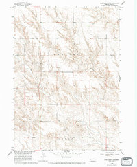
1966 Map of Sand Canyon West
USGS Topo · Published 1993About this map
Antelope Canyon dominates the central portion of this 1960s survey, illustrating the complex drainage patterns of the Dawes County landscape. The terrain is defined by the winding course of Pepper Creek, which cuts through the high plains of the Nebraska Panhandle. This area, part of the Department of the Interior program for the development of the Missouri River Basin, shows a sparse but functional infrastructure. A solitary Substation sits near the southern boundary in the Craig precinct, a reminder of the rural electrification and utility expansion that reached these remote sections of the state during the mid-20th century. The map provides a meticulous record of fence lines and field boundaries as they existed in the years following the 1965 aerial photography and 1966 field check.
Find a feature on this map
7 named features on this map. Tap any name to fly to it.
Don’t see what you’re looking for? This feature index may not catch every label — zoom into the map to look around manually.
Map Details
Editions of this 1966 Sand Canyon West Map
2 editions found
Other maps of this area

1947 · Box Butte NE
USGS Topo · 1:24,000

1947 · Box Butte NW
USGS Topo · 1:24,000

1948 · Box Butte Reservoir East
USGS Topo · 1:24,000

1949 · Box Butte NE
USGS Topo · 1:24,000

1949 · Box Butte NW
USGS Topo · 1:24,000

1955 · Alliance
USGS Topo · 1:250,000

1957 · Alliance
USGS Topo · 1:250,000

1958 · Alliance
USGS Topo · 1:250,000

1966 · Chadron 3 SE
USGS Topo · 1:24,000

1966 · Chadron 3 NE
USGS Topo · 1:24,000