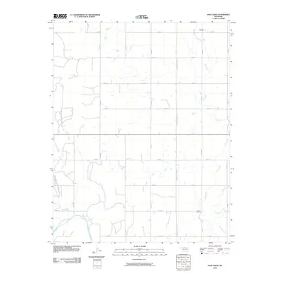
2009 Map of Sand Creek
USGS Topo · Published 2009About this map
Salt Fork Arkansas River sweeps through the southwest corner of this northern Oklahoma landscape, defining the hydrology of a region dominated by a precise section-line road grid. The terrain is shaped by the southward flow of Sand Creek and its tributary Crooked Creek, which meander through the agricultural plains of Grant County. While the physical settlements are sparse, the map preserves the locations of local landmarks vital to genealogical research, such as Hawley Cemetery in the southeast and Fairview Cemetery near the northern boundary. Centered along Oklahoma State Hwy 132, the map illustrates a rural environment where modern infrastructure, including numerous county roads like E0150 Rd and N2770 Rd, maintains the traditional land divisions established during the state's early development.
Find a feature on this map
20 named features on this map. Tap any name to fly to it.
Don’t see what you’re looking for? This feature index may not catch every label — zoom into the map to look around manually.
Map Details
Editions of this 2009 Sand Creek Map
This is the sole edition of this map. No revisions or reprints were ever made.
Other maps of this area

1955 · Enid
USGS Topo · 1:250,000

1955 · Woodward
USGS Topo · 1:250,000

1958 · Enid
USGS Topo · 1:250,000

1958 · Woodward
USGS Topo · 1:250,000

1968 · Wakita
USGS Topo · 1:24,000

1968 · Pond Creek NW
USGS Topo · 1:24,000

1968 · Wakita SW
USGS Topo · 1:24,000

1969 · Jet
USGS Topo · 1:24,000
1969 · Manchester
USGS Topo · 1:24,000

1969 · Nash
USGS Topo · 1:24,000