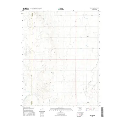
2016 Map of Sand Creek
USGS Topo · Published 2016About this map
Hawley and the surrounding plains of eastern Grant County are defined by a regular grid of section roads and the winding path of the Salt Fork Arkansas River. The settlement of Sand Creek sits along its namesake waterway, which drains the northern portion of this landscape. Local genealogy is anchored by the Hawley Cem and Fairview Cem, serving the farming families who established these communities. The topography is relatively flat, punctuated by the occasional natural water source like Sarah Spring. The map documents a classic Oklahoma agricultural layout, where namesake family roads such as Johnston Rd, Jefferson Rd, and Harmon Rd delineate the boundaries of long-held homesteads and rural properties.
Find a feature on this map
38 named features on this map. Tap any name to fly to it.
Don’t see what you’re looking for? This feature index may not catch every label — zoom into the map to look around manually.
Map Details
Editions of this 2016 Sand Creek Map
This is the sole edition of this map. No revisions or reprints were ever made.
Other maps of this area

1955 · Enid
USGS Topo · 1:250,000

1955 · Woodward
USGS Topo · 1:250,000

1958 · Enid
USGS Topo · 1:250,000

1958 · Woodward
USGS Topo · 1:250,000

1968 · Wakita
USGS Topo · 1:24,000

1968 · Pond Creek NW
USGS Topo · 1:24,000

1968 · Wakita SW
USGS Topo · 1:24,000

1969 · Jet
USGS Topo · 1:24,000
1969 · Manchester
USGS Topo · 1:24,000

1969 · Nash
USGS Topo · 1:24,000