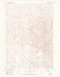
1958 Map of Sand Draw
USGS Topo · Published 1979About this map
Big Sand Draw Oil and Gas Field dominates this landscape, showing a complex network of energy infrastructure as it appeared during the mid-20th century. The settlement of Sand Draw serves as a central hub, featuring a Sand Draw Post Office and an adjacent Airfield. The extraction economy is further evidenced by the Sand Draw Coal Mine and numerous Oil Wells scattered across the North Sand Draw Unit and Alkali Butte Unit.
Find a feature on this map
26 named features on this map. Tap any name to fly to it.
Don’t see what you’re looking for? This feature index may not catch every label — zoom into the map to look around manually.
Map Details
Editions of this 1958 Sand Draw Map
3 editions found
Other maps of this area

1953 · Blue Gulch
USGS Topo · 1:24,000

1953 · Arapahoe NE
USGS Topo · 1:24,000

1953 · Bringolf Ranch
USGS Topo · 1:24,000

1953 · Elkhorn Springs
USGS Topo · 1:24,000

1953 · Campbell Ridge
USGS Topo · 1:24,000

1953 · Sand Draw
USGS Topo · 1:24,000

1953 · Dishpan Butte
USGS Topo · 1:24,000

1953 · Yellowstone Ranch
USGS Topo · 1:24,000

1955 · Lander
USGS Topo · 1:250,000

1958 · Lander
USGS Topo · 1:250,000