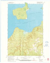
1964 Map of Sand Island
USGS Topo · Published 1991About this map
Sand Island sits at the northern edge of this Lake Superior survey, anchored by its northern Light and a network of interior trails and jeep trails. The island's geography is defined by sheltered inlets like Lighthouse Bay, Justice Bay, and West Bay. On the mainland, the Red Cliff Indian Reservation encompasses much of the coastal forest and drainage systems. The landscape is marked by the winding courses of the Sand River and Raspberry River, which flow north toward the shore. In the township of Russell, several gravel pits suggest local extraction efforts during this mid-century period. The small settlement at Sand Bay and the proximity of York Island to the east illustrate the maritime-dependent character of this portion of the Apostle Islands.
Find a feature on this map
24 named features on this map. Tap any name to fly to it.
Don’t see what you’re looking for? This feature index may not catch every label — zoom into the map to look around manually.
Map Details
Editions of this 1964 Sand Island Map
2 editions found
Other maps of this area

1941 · Bayfield
USGS Topo · 1:48,000

1944 · Cornucopia
USGS Topo · 1:48,000

1946 · Cornucopia
USGS Topo · 1:48,000

1946 · Bayfield
USGS Topo · 1:48,000

1953 · Ashland
USGS Topo · 1:250,000

1954 · Two Harbors
USGS Topo · 1:250,000

1957 · Two Harbors
USGS Topo · 1:250,000

1958 · Ashland
USGS Topo · 1:250,000

1958 · Two Harbors
USGS Topo · 1:250,000
1963 · Bear Island
USGS Topo · 1:24,000