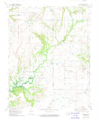
1972 Map of Sanders
USGS Topo · Published 1974About this map
The northern reaches of Oologah Lake dominate the southwestern corner of this survey, where the waters meet the confluence of Big Creek and Coal Creek. The landscape transitions from the inundated river valley into the rolling terrain of the Armstrong district, characterized by intermittent drainages like Blue Canyon and Snow Creek. Small-scale settlement patterns are evident near the Sanders locale, supported by community fixtures such as the Twin Bridges Community Center and religious sites like Happy Hill Ch. Local family history is rooted in the land at the Halsell Ranch and documented at Martin Cem. The map also traces the county line between Nowata and Craig Counties, following the meandering path of Big Creek past small industrial markers like a Gravel Pit and scattered Drill Hole locations, reflecting the rural and extractive character of the region during the early 1970s.
Find a feature on this map
25 named features on this map. Tap any name to fly to it.
Don’t see what you’re looking for? This feature index may not catch every label — zoom into the map to look around manually.
Map Details
Editions of this 1972 Sanders Map
This is the sole edition of this map. No revisions or reprints were ever made.
Other maps of this area

1901 · Nowata
USGS Topo · 1:125,000

1901 · Vinita
USGS Topo · 1:125,000

1913 · Vinita
USGS Topo · 1:125,000

1914 · Nowata
USGS Topo · 1:125,000

1954 · Tulsa
USGS Topo · 1:250,000

1958 · Tulsa
USGS Topo · 1:250,000

1963 · Tulsa
USGS Topo · 1:250,000
1972 · Estella
USGS Topo · 1:24,000
1972 · Chelsea NW
USGS Topo · 1:24,000
1972 · Nowata East
USGS Topo · 1:24,000