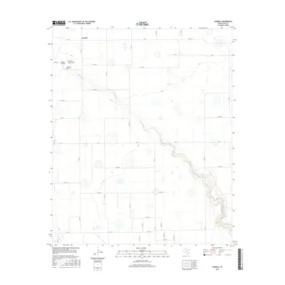
2016 Map of Sandhill
USGS Topo · Published 2016About this map
Sandhill sits atop the high plains of Floyd County, where the flat agricultural landscape is dramatically interrupted by the carved descent into Blanco Canyon. The White River winds through this deeply incised canyon floor, creating a stark contrast between the gridded section lines of the surrounding plateau and the meandering, topographically complex river valley. This 2016 survey illustrates a classic Llano Estacado landscape, where seasonal drainages like Running Water Draw and Callahan Draw converge to feed the canyon system. Within this environment, localized water management is evident at Bois d'Arc Lake and W F Daniel Lake, while the extreme southwest corner reveals the headwaters of Crawfish Cr. The map captures a rural Texas economy defined by a dense network of county roads and farm-to-market routes, including FM 784 and FM 37, which service the scattered farmsteads and ranch lands of the region.
Find a feature on this map
39 named features on this map. Tap any name to fly to it.
Don’t see what you’re looking for? This feature index may not catch every label — zoom into the map to look around manually.
Map Details
Editions of this 2016 Sandhill Map
This is the sole edition of this map. No revisions or reprints were ever made.
Other maps of this area

1954 · Lubbock
USGS Topo · 1:250,000

1954 · Plainview
USGS Topo · 1:250,000

1958 · Plainview
USGS Topo · 1:250,000

1965 · Petersburg
USGS Topo · 1:24,000

1965 · Lockney SE
USGS Topo · 1:24,000

1965 · Cone
USGS Topo · 1:24,000

1965 · Floydada
USGS Topo · 1:24,000

1965 · Lockney
USGS Topo · 1:24,000

1965 · Floydada SE
USGS Topo · 1:24,000

1965 · Sandhill
USGS Topo · 1:24,000