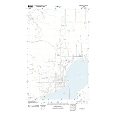
2011 Map of Sandpoint
USGS Topo · Published 2011About this map
Sandpoint sits at the nexus of major regional transportation and recreation where the northern reaches of Lake Pend Oreille meet the complex waterways of Chuck Slough and Sand Creek. This 2011 survey documents the city's modern layout alongside the neighboring communities of Ponderay and Kootenai, illustrating the shift from a rail-centered hub to a contemporary regional center. The map captures the significant aviation presence in the valley, including the primary Sandpoint Airport, the Olmstead Sky Ranch, and Murray Airport to the northeast.
Find a feature on this map
57 named features on this map. Tap any name to fly to it.
Don’t see what you’re looking for? This feature index may not catch every label — zoom into the map to look around manually.
Map Details
Editions of this 2011 Sandpoint Map
This is the sole edition of this map. No revisions or reprints were ever made.
Other maps of this area

1901 · Sandpoint
USGS Topo · 1:125,000

1911 · Priest Lake
USGS Topo · 1:250,000

1911 · Sandpoint
USGS Topo · 1:125,000

1913 · Priest Lake
USGS Topo · 1:250,000

1949 · Packsaddle Mtn
USGS Topo · 1:62,500

1951 · Packsaddle Mtn
USGS Topo · 1:62,500

1951 · Elmira
USGS Topo · 1:62,500

1958 · Sandpoint
USGS Topo · 1:250,000

1963 · Sandpoint
USGS Topo · 1:250,000
1968 · Happy Fork Gap
USGS Topo · 1:24,000