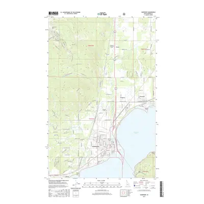
2017 Map of Sandpoint
USGS Topo · Published 2017About this map
Lake Pend Oreille defines the eastern boundary of this Bonner County landscape, where the waters of Kootenai Bay meet the shoreline settlements of Ponder Point and Kootenai. The city of Sandpoint sits at the heart of the region, its street grid transitioning from the historic downtown to residential areas near Pinecrest Cem and Lakeview Cem. To the north, the terrain rises sharply into the Schweitzer Basin, a complex of recreation-focused trails like Telemark Trail and Highpoint Trail that contrast with the industrial and aviation hubs found at the Sandpoint Airport and Olmstead Sky Ranch Airport. This 2017 survey reveals a diverse mix of lakefront living, mountainous terrain, and essential infrastructure, including the path of the Great Northern Rd, illustrating the development patterns of the Idaho Panhandle in the early twenty-first century.
Find a feature on this map
162 named features on this map. Tap any name to fly to it.
Don’t see what you’re looking for? This feature index may not catch every label — zoom into the map to look around manually.
Map Details
Editions of this 2017 Sandpoint Map
This is the sole edition of this map. No revisions or reprints were ever made.
Other maps of this area

1901 · Sandpoint
USGS Topo · 1:125,000

1911 · Priest Lake
USGS Topo · 1:250,000

1911 · Sandpoint
USGS Topo · 1:125,000

1913 · Priest Lake
USGS Topo · 1:250,000

1949 · Packsaddle Mtn
USGS Topo · 1:62,500

1951 · Packsaddle Mtn
USGS Topo · 1:62,500

1951 · Elmira
USGS Topo · 1:62,500

1958 · Sandpoint
USGS Topo · 1:250,000

1963 · Sandpoint
USGS Topo · 1:250,000
1968 · Happy Fork Gap
USGS Topo · 1:24,000