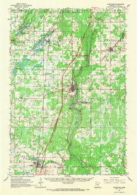
1961 Map of Sandstone
USGS Topo · Published 1970About this map
The Kettle River carves a deep path through central Pine County, anchoring a landscape defined by its industrial quarries and the prominent Sandstone Federal Correctional Institution. The settlement pattern of the early 1960s reveals a cluster of smaller communities and vanished landmarks, such as the Banning Ruins located along the river bluffs north of Sandstone. This era captures a transition in local infrastructure, showing the Great Northern and Northern Pacific railroads still intersecting the terrain near Hinckley and Finlayson.
Find a feature on this map
60 named features on this map. Tap any name to fly to it.
Don’t see what you’re looking for? This feature index may not catch every label — zoom into the map to look around manually.
Map Details
Editions of this 1961 Sandstone Map
2 editions found
Other maps of this area

1950 · Grantsburg
USGS Topo · 1:48,000

1953 · Duluth
USGS Topo · 1:250,000

1953 · Stillwater
USGS Topo · 1:250,000

1955 · Stillwater
USGS Topo · 1:250,000

1958 · Stillwater
USGS Topo · 1:250,000

1958 · Duluth
USGS Topo · 1:250,000

1961 · Sandstone
USGS Topo · 1:62,500

1961 · Moose Lake
USGS Topo · 1:62,500

1961 · Brook Park
USGS Topo · 1:62,500

1961 · Pine City
USGS Topo · 1:62,500