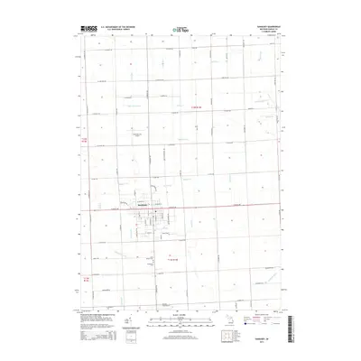
2014 Map of Sandusky
USGS Topo · Published 2014About this map
Sandusky serves as the focal point of this Sanilac County landscape, situated within a dense grid of agricultural roads and an extensive network of drainage infrastructure. The town's layout is defined by the intersection of W Sanilac Rd and N Sandusky Rd, with aviation hubs like the Sandusky City Airport and Cowley Field Airport flanking the settlement to the north and south. This survey reveals a terrain heavily managed for agriculture, marked by dozens of named waterways such as the Black River and Beals Frizzle Drain. For genealogists and local historians, the map provides precise locations for Saint Joseph's Cem and Greenwood Cem, both situated south of the main town center. The naming conventions of the drainage system, including Baerwolf Drain and O'Connell Drain, reflect the family names of the area's early landholders and the vital role of water management in Michigan's Thumb region.
Find a feature on this map
88 named features on this map. Tap any name to fly to it.
Don’t see what you’re looking for? This feature index may not catch every label — zoom into the map to look around manually.
Map Details
Editions of this 2014 Sandusky Map
This is the sole edition of this map. No revisions or reprints were ever made.
Other maps of this area

1954 · Flint
USGS Topo · 1:250,000

1958 · Flint
USGS Topo · 1:250,000

1963 · Snover
USGS Topo · 1:24,000

1963 · Sandusky
USGS Topo · 1:24,000

1963 · Peck
USGS Topo · 1:24,000

1963 · Juhl
USGS Topo · 1:24,000

1963 · Palms
USGS Topo · 1:24,000

1963 · Applegate
USGS Topo · 1:24,000

1963 · Deckerville
USGS Topo · 1:24,000

1963 · Argyle
USGS Topo · 1:24,000