
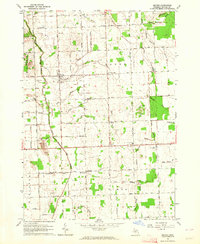
1963 Map of Snover
USGS Topo · Published 1964About this map
Snover serves as the central hub of this agricultural landscape in Sanilac County, where a grid of rural roads connects several distinct school districts and small settlements. The community is defined by its social infrastructure, including the Snover Memorial Park and various rural institutions such as the Wilson Sch and Urban Sch. An Old Railroad Grade cuts east-west through the center of the township, passing just south of Turtle Creek, reflecting the historical rail-dependent economy of this part of Michigan's Thumb region.
Find a feature on this map
45 named features on this map. Tap any name to fly to it.
Don’t see what you’re looking for? This feature index may not catch every label — zoom into the map to look around manually.
Map Details
Editions of this 1963 Snover Map
2 editions found
Other maps of this area

1954 · Flint
USGS Topo · 1:250,000

1958 · Flint
USGS Topo · 1:250,000

1963 · Sandusky
USGS Topo · 1:24,000

1963 · Peck
USGS Topo · 1:24,000

1963 · Juhl
USGS Topo · 1:24,000

1963 · Marlette
USGS Topo · 1:24,000

1963 · Palms
USGS Topo · 1:24,000

1963 · Shabbona
USGS Topo · 1:24,000
1963 · Decker
USGS Topo · 1:24,000

1963 · Argyle
USGS Topo · 1:24,000