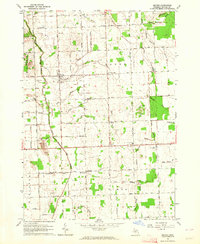
1963 Map of Snover
USGS Topo · Published 1964About this map
The Chesapeake and Ohio Railroad bisects this Sanilac County landscape, passing through the village of Snover and over Turtle Creek. The area is defined by a dense network of agricultural drainage systems, including the Mushroom Drain and Ryder Drain, which feed into the South Branch Cass River. This 1963 survey captures the rural character of Moore and Elmer townships, where small settlements like Gerstenberger and Minard are anchored by local institutions such as the Elmer Sch and Minard Sch. The proximity of the Brethren in Christ Ch and the Townhall in Snover suggests a well-established community center during this era. Scattered Gravel Pits and family-named schools like Hyslop Sch illustrate the localized industry and decentralized education system typical of mid-century Michigan farm country.
Find a feature on this map
62 named features on this map. Tap any name to fly to it.
Don’t see what you’re looking for? This feature index may not catch every label — zoom into the map to look around manually.
Map Details
Editions of this 1963 Snover Map
2 editions found
Other maps of this area

1954 · Flint
USGS Topo · 1:250,000

1958 · Flint
USGS Topo · 1:250,000

1963 · Snover
USGS Topo · 1:24,000

1963 · Sandusky
USGS Topo · 1:24,000

1963 · Peck
USGS Topo · 1:24,000

1963 · Juhl
USGS Topo · 1:24,000

1963 · Marlette
USGS Topo · 1:24,000

1963 · Palms
USGS Topo · 1:24,000

1963 · Shabbona
USGS Topo · 1:24,000
1963 · Decker
USGS Topo · 1:24,000