
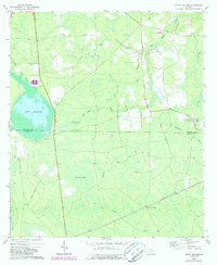
1972 Map of Sandy Bottom
USGS Topo · Published 1977About this map
Guest Millpond dominates the western landscape of this South Georgia survey, illustrating the critical role of water management in this low-lying region. Straddling the Atkinson and Clinch County line, the map reveals a mosaic of wetland features including Pee Dee Bay, Old Ninety Bay, and the expansive Arabia Swamp. These depressions, or "bays," define the local topography, alongside the drainage of Red Bluff Creek and Suwannee Creek.
Find a feature on this map
24 named features on this map. Tap any name to fly to it.
Don’t see what you’re looking for? This feature index may not catch every label — zoom into the map to look around manually.
Map Details
Editions of this 1972 Sandy Bottom Map
2 editions found
Other maps of this area

1953 · Waycross
USGS Topo · 1:250,000

1958 · Waycross
USGS Topo · 1:250,000

1968 · Homerville East
USGS Topo · 1:24,000

1968 · Cogdell
USGS Topo · 1:24,000

1971 · Axson
USGS Topo · 1:24,000

1971 · Pearson
USGS Topo · 1:24,000

1972 · Kirkland
USGS Topo · 1:24,000

1972 · Sirmans
USGS Topo · 1:24,000

1972 · Henderson Still
USGS Topo · 1:24,000
1978 · Henderson Still
USGS Topo · 1:24,000