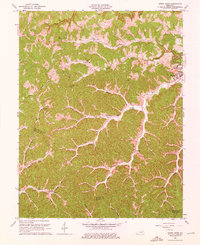
1962 Map of Sandy Hook
USGS Topo · Published 1976About this map
Sandy Hook serves as the focal point for this mid-century survey of Elliott and Morgan Counties, where the Little Sandy River and its various forks carve through the landscape. The geography is defined by a dendritic drainage pattern, with settlements like Lytten, The Ridge, and Bigstone situated along the high ground and narrow valley floors. Evidence of rural life is scattered throughout the hills, including the Carter Sch, Pine Grove Sch, and numerous cemeteries tucked into the hollows.
Find a feature on this map
45 named features on this map. Tap any name to fly to it.
Don’t see what you’re looking for? This feature index may not catch every label — zoom into the map to look around manually.
Map Details
Editions of this 1962 Sandy Hook Map
4 editions found
Other maps of this area

1889 · Salyersville
USGS Topo · 1:125,000

1891 · Salyersville
USGS Topo · 1:125,000

1899 · Salyersville
USGS Topo · 1:125,000

1929 · Morehead
USGS Topo · 1:48,000

1935 · Morehead
USGS Topo · 1:62,500

1950 · Bruin
USGS Topo · 1:24,000

1950 · Isonville
USGS Topo · 1:24,000

1950 · Ault
USGS Topo · 1:24,000

1950 · Sandy Hook
USGS Topo · 1:24,000

1950 · Lenox
USGS Topo · 1:24,000