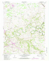
1957 Map of Sango
USGS Topo · Published 1984About this map
The Red River meanders sharply through the Montgomery County countryside, creating a complex series of oxbows and deep river bends that define this mid-century landscape. At the confluence of the river and Sulphur Fork, Port Royal State Park preserves a site of significant early Tennessee commerce, where historic tobacco transit once thrived. The map documents a dense network of country congregations, including Hollins Chapel, Corinth Ch, and Mt Zion Ch, which served the rural farming communities of Sango and Kirkwood. Near the western edge, the expansion of Clarksville is evident through the presence of Interchange 11 and the Rest Haven Memorial Gardens. The northern reaches are bisected by the Seaboard System Railroad, which passes through Hampton Station as it cuts across the undulating terrain toward the Kentucky border.
Find a feature on this map
35 named features on this map. Tap any name to fly to it.
Don’t see what you’re looking for? This feature index may not catch every label — zoom into the map to look around manually.
Map Details
Editions of this 1957 Sango Map
5 editions found
Other maps of this area

1944 · Clarksville
USGS Topo · 1:50,000

1950 · Allensville
USGS Topo · 1:24,000

1950 · Guthrie
USGS Topo · 1:24,000

1951 · Hammacksville
USGS Topo · 1:24,000

1951 · Clarksville
USGS Topo · 1:24,000

1956 · Nashville
USGS Topo · 1:250,000

1957 · Adams
USGS Topo · 1:24,000

1957 · Pleasant View
USGS Topo · 1:24,000

1957 · Henrietta
USGS Topo · 1:24,000

1957 · Sango
USGS Topo · 1:24,000