
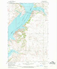
1967 Map of Sanish
USGS Topo · Published 1969About this map
Lake Sakakawea dominates this mid-century landscape, a flooded segment of the Missouri River valley that reshaped the geography of the Fort Berthold Indian Reservation. The map captures the settlement of Sanish perched above the water, near the point where the Four Bears Memorial Bridge spans the reservoir to connect Mountrail and McKenzie counties. Significant changes in transportation are evident along the shoreline, most notably the Old Railroad Grade winding through the hills, a remnant of the rail infrastructure displaced by the rising waters. Local social and religious centers are scattered through the uplands, including Grand Valley Ch and the Riverview Cemetery, while recreational and cultural sites like Four Bears State Park and the Crow Flies High Butte Historic Site highlight the era's focus on the new shoreline's public and historical value.
Find a feature on this map
21 named features on this map. Tap any name to fly to it.
Don’t see what you’re looking for? This feature index may not catch every label — zoom into the map to look around manually.
Map Details
Editions of this 1967 Sanish Map
2 editions found
Other maps of this area

1953 · Williston
USGS Topo · 1:250,000

1953 · Watford City
USGS Topo · 1:250,000

1957 · Williston
USGS Topo · 1:250,000

1957 · Watford City
USGS Topo · 1:250,000

1967 · Watford City
USGS Topo · 1:250,000

1967 · Sanish NW
USGS Topo · 1:24,000

1967 · Sanish SE
USGS Topo · 1:24,000

1967 · New Town SW
USGS Topo · 1:24,000

1967 · Sanish SW
USGS Topo · 1:24,000

1981 · Belden SW
USGS Topo · 1:24,000