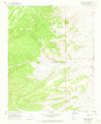
1966 Map of Sanostee West
USGS Topo · Published 1969About this map
Beautiful Mountain dominates the western high ground of this high-desert landscape within the Navajo Indian Reservation. The terrain is defined by a complex drainage network where Sanostee Wash and Tse-clani-to Wash cut through deep canyons and wide alluvial flats. This 1960s survey illustrates a rural infrastructure centered on intermittent water sources, featuring essential utilities like a Sewage Disposal site and a remote Well. To the east, Rock Ridge provides a distinct geological boundary above the lower reaches of Pajarito Creek. The map documents a period of specialized land use in San Juan County, where the relationship between seasonal watercourses and the arid environment dictated the placement of small-scale improvements and access points across the reservation.
Find a feature on this map
11 named features on this map. Tap any name to fly to it.
Don’t see what you’re looking for? This feature index may not catch every label — zoom into the map to look around manually.
Map Details
Editions of this 1966 Sanostee West Map
2 editions found
Other maps of this area

1889 · Chaco
USGS Topo · 1:250,000

1892 · Chaco
USGS Topo · 1:250,000

1892 · Canyon De Chelly
USGS Topo · 1:250,000

1934 · Ship Rock
USGS Topo · 1:62,500

1937 · Ship Rock
USGS Topo · 1:62,500

1953 · Sanostee
USGS Topo · 1:62,500

1953 · Redrock Valley SE
USGS Topo · 1:24,000

1953 · Redrock Valley
USGS Topo · 1:62,500

1954 · Shiprock
USGS Topo · 1:250,000

1955 · Sonsala Butte 1 SE
USGS Topo · 1:24,000