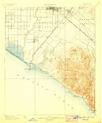
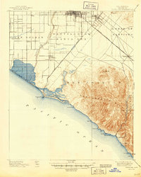
1901 Map of Santa Ana
USGS Topo · Published 1907About this map
Santa Ana sits at the heart of a rapidly developing coastal plain in the decade following its incorporation as the county seat. The landscape is a mosaic of emerging settlements and agricultural tracts, connected by a network of rail lines including the Southern California R.R. (Surf Line) and the Southern Pacific R.R. (Newport Branch). To the west, the wetland environments of La Bolsa Chica and Las Bolsas contrast with the rising elevations of the San Joaquin Hills and Lomas de Santiago to the east. The Santa Ana River carves through the central valley, feeding into the expansive Newport Bay. Coastal life is evident in the burgeoning resorts at Newport Beach, Laguna, and Arch Beach, while inland hamlets like Tustin, Smeltzer, and Celery reflect the region's early citrus and lima bean industries.
Find a feature on this map
39 named features on this map. Tap any name to fly to it.
Don’t see what you’re looking for? This feature index may not catch every label — zoom into the map to look around manually.
Map Details
Editions of this 1901 Santa Ana Map
6 editions found
Other maps of this area

1896 · Santa Ana
USGS Topo · 1:62,500

1896 · Anaheim
USGS Topo · 1:62,500

1896 · Las Bolsas
USGS Topo · 1:62,500

1896 · Downey
USGS Topo · 1:62,500

1898 · Anaheim
USGS Topo · 1:62,500

1899 · Downey
USGS Topo · 1:62,500

1901 · Southern California Sheet No. 1
USGS Topo · 1:250,000

1901 · Santa Ana
USGS Topo · 1:62,500

1901 · Anaheim
USGS Topo · 1:62,500

1902 · Capistrano
USGS Topo · 1:125,000