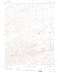
1972 Map of Santa Clara
USGS Topo · Published 1974About this map
North Santa Clara Creek and South Santa Clara Creek define the rugged drainage patterns of this high-altitude landscape along the border of Huerfano and Las Animas counties. In the early 1970s, the area remained largely defined by its natural topography and isolated water sources, such as Upper Duhme Springs, Lower Duhme Spring, and the Santa Clara Windmill. A history of local settlement is anchored by the Thomas Roger Cem and Ortiz Sch, which sit near Mauricio Canyon at the southern edge of the quadrangle. The map captures a transition from structured transportation routes like Ideal Road and Rouse Road in the north to a network of jeep trails and footpaths that navigate the complex terrain of Black Hawk Canyon and Schultz Canyon.
Find a feature on this map
29 named features on this map. Tap any name to fly to it.
Don’t see what you’re looking for? This feature index may not catch every label — zoom into the map to look around manually.
Map Details
Editions of this 1972 Santa Clara Map
4 editions found
Other maps of this area

1891 · Walsenburg
USGS Topo · 1:125,000

1891 · Spanish Peaks
USGS Topo · 1:125,000

1893 · Spanish Peaks
USGS Topo · 1:125,000

1894 · Walsenburg
USGS Topo · 1:125,000

1895 · Spanish Peaks
USGS Topo · 1:125,000

1897 · Walsenburg
USGS Topo · 1:125,000

1897 · Spanish Peaks
USGS Topo · 1:125,000

1900 · Spanish Peaks
USGS Topo · 1:125,000

1900 · Walsenburg
USGS Topo · 1:125,000

1954 · Trinidad
USGS Topo · 1:250,000