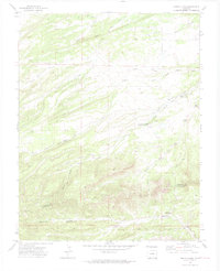
1972 Map of Santa Clara
USGS Topo · Published 1974About this map
The rugged drainage systems of Santa Clara Creek and its north and south forks dominate this 1970s landscape on the boundary of Huerfano and Las Animas counties. This map captures a transition between the elevated terrain of the Sangre de Cristo foothills and the lower arroyos, marked by geologic features like the Small Dyke. Significant for local family historians, the sheet identifies the Thomas Roger Cem and the Ortiz Sch, reflecting the sparse but established rural infrastructure of this ranching and mining region. Water sources are meticulously documented, including named points like Upper Duhme Springs, Boiler Spring, and the Santa Clara Windmill. A network of thoroughfares such as Ideal Road and Rouse Road, alongside various jeep trails, provide a clear record of the area's twentieth-century accessibility for those tracing land use or ancestry in these southern Colorado canyons.
Find a feature on this map
25 named features on this map. Tap any name to fly to it.
Don’t see what you’re looking for? This feature index may not catch every label — zoom into the map to look around manually.
Map Details
Editions of this 1972 Santa Clara Map
4 editions found
Other maps of this area

1891 · Walsenburg
USGS Topo · 1:125,000

1891 · Spanish Peaks
USGS Topo · 1:125,000

1893 · Spanish Peaks
USGS Topo · 1:125,000

1894 · Walsenburg
USGS Topo · 1:125,000

1895 · Spanish Peaks
USGS Topo · 1:125,000

1897 · Walsenburg
USGS Topo · 1:125,000

1897 · Spanish Peaks
USGS Topo · 1:125,000

1900 · Spanish Peaks
USGS Topo · 1:125,000

1900 · Walsenburg
USGS Topo · 1:125,000

1954 · Trinidad
USGS Topo · 1:250,000