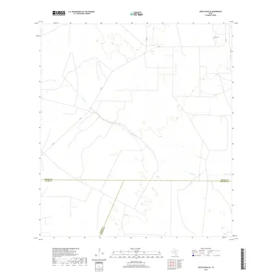
2019 Map of Santa Elena SE
USGS Topo · Published 2019About this map
The tri-county intersection of Brooks, Starr, and Hidalgo counties defines this landscape in South Texas. The terrain is characterized by the ephemeral drainage of Vargas Cr, which meanders across a largely rural expanse dedicated to ranching and open space. Human activity is concentrated along the arterial corridor of Fm 755, with secondary access provided by local routes like Co Rd 315 and Co Rd 311. A significant site for local family history is La Mesa Cem, located in the northeastern quadrant near the Brooks County line. The map illustrates a sparse settlement pattern typical of the Brush Country, where land use is dictated by the subtle topography of the Rio Grande Valley hinterlands.
Find a feature on this map
8 named features on this map. Tap any name to fly to it.
Don’t see what you’re looking for? This feature index may not catch every label — zoom into the map to look around manually.
Map Details
Editions of this 2019 Santa Elena SE Map
This is the sole edition of this map. No revisions or reprints were ever made.
Other maps of this area

1939 · Linn
USGS Topo · 1:62,500

1939 · La Reforma
USGS Topo · 1:62,500

1939 · Encantada
USGS Topo · 1:62,500

1949 · Mc Allen
USGS Topo · 1:250,000

1954 · McAllen
USGS Topo · 1:250,000

1957 · Mc Allen
USGS Topo · 1:250,000

1962 · McAllen
USGS Topo · 1:250,000
1963 · Encino
USGS Topo · 1:24,000

1963 · Linn NW
USGS Topo · 1:24,000
1963 · Hartland
USGS Topo · 1:24,000