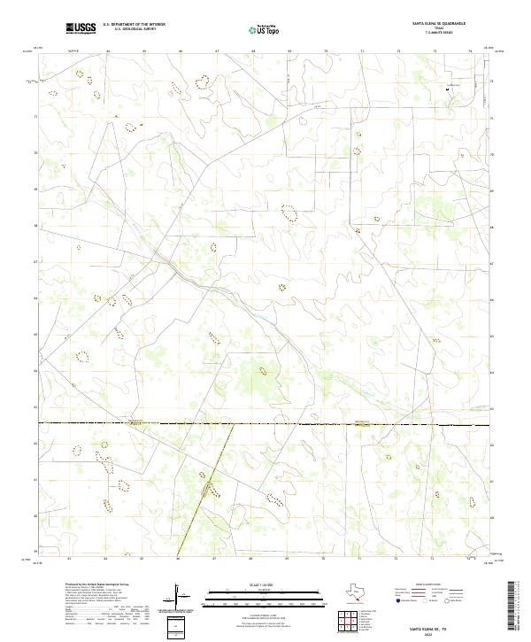
2022 Map of Santa Elena SE
USGS Topo · Published 2022About this map
Vargas Cr winds through this quiet stretch of South Texas brushland, marking the primary drainage in a landscape defined by ranching and low-density land use. The map highlights the tri-county junction where Brooks, Starr, and Hidalgo counties meet. This intersection of boundaries underscores the region's historical partitioning for large-scale land grants and agricultural interests. For genealogists and local historians, the presence of La Mesa Cem in the northeast corner serves as a vital anchor for family research in an otherwise sparsely populated area. The sparse network of routes, including FM 755, Co Rd 315, and Co Rd 311, indicates the persistent rural character of this territory as it remained well into the twenty-first century.
Find a feature on this map
8 named features on this map. Tap any name to fly to it.
Don’t see what you’re looking for? This feature index may not catch every label — zoom into the map to look around manually.
Map Details
Editions of this 2022 Santa Elena SE Map
This is the sole edition of this map. No revisions or reprints were ever made.
Other maps of this area

1939 · Linn
USGS Topo · 1:62,500

1939 · La Reforma
USGS Topo · 1:62,500

1939 · Encantada
USGS Topo · 1:62,500

1949 · Mc Allen
USGS Topo · 1:250,000

1954 · McAllen
USGS Topo · 1:250,000

1957 · Mc Allen
USGS Topo · 1:250,000

1962 · McAllen
USGS Topo · 1:250,000
1963 · Encino
USGS Topo · 1:24,000

1963 · Linn NW
USGS Topo · 1:24,000
1963 · Hartland
USGS Topo · 1:24,000