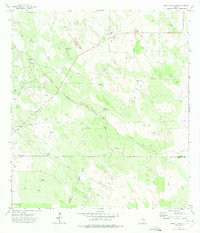
1972 Map of Santa Elena SE
USGS Topo · Published 1975About this map
The south Texas rangelands in the early 1970s are defined here by a network of water-drawing infrastructure and energy development. This arid landscape, centered where the borders of Brooks, Starr, and Hidalgo counties converge, relies heavily on landmarks like Pita Windmill, Registre Windmill, and Juarez Well to sustain local ranching operations. The terrain is notably marked by Vargas Creek and the low elevations of Las Montas, while the subterranean economy is evident through numerous Oil Wells and a Gas Plant.
Find a feature on this map
23 named features on this map. Tap any name to fly to it.
Don’t see what you’re looking for? This feature index may not catch every label — zoom into the map to look around manually.
Map Details
Editions of this 1972 Santa Elena SE Map
2 editions found
Other maps of this area

1939 · Linn
USGS Topo · 1:62,500

1939 · La Reforma
USGS Topo · 1:62,500

1939 · Encantada
USGS Topo · 1:62,500

1949 · Mc Allen
USGS Topo · 1:250,000

1954 · McAllen
USGS Topo · 1:250,000

1957 · Mc Allen
USGS Topo · 1:250,000

1962 · McAllen
USGS Topo · 1:250,000
1963 · Encino
USGS Topo · 1:24,000

1963 · Linn NW
USGS Topo · 1:24,000
1963 · Hartland
USGS Topo · 1:24,000