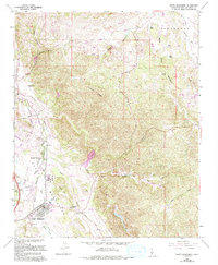
1965 Map of Santa Margarita
USGS Topo · Published 1994About this map
Santa Margarita and its immediate surroundings are captured here at a moment of mid-century transition, showing the intersection of rural ranching and growing residential pockets. The Southern Pacific railroad corridor serves as the primary north-south spine, running alongside the Salinas River and anchoring the settlements of Cushing and Garden Farms. The map illustrates a landscape of distinct elevation changes, with the prominent spine of Granite Ridge and the distinct formation of Chalk Hill overlooking the river valley. To the south, the village of Santa Margarita is detailed with its street grid, the Santa Margarita Cemetery, and a nearby Mobile Home Park, reflecting local development. Ranching heritage remains visible through named locations like Happy Valley Ranch, while various creek branches like Trout Creek and Huerhuero Creek delineate the drainage patterns of this San Luis Obispo County landscape.
Find a feature on this map
30 named features on this map. Tap any name to fly to it.
Don’t see what you’re looking for? This feature index may not catch every label — zoom into the map to look around manually.
Map Details
Editions of this 1965 Santa Margarita Map
3 editions found
Other maps of this area

1897 · San Luis Obispo
USGS Topo · 1:62,500

1900 · San Luis
USGS Topo · 1:125,000

1914 · Cholame
USGS Topo · 1:125,000

1915 · Cholame
USGS Topo · 1:125,000

1917 · Cholame
USGS Topo · 1:125,000

1919 · Paso Robles
USGS Topo · 1:62,500

1922 · Pozo
USGS Topo · 1:62,500

1942 · San Luis Obispo
USGS Topo · 1:62,500

1943 · Paso Robles
USGS Topo · 1:62,500

1943 · Shedd Canyon
USGS Topo · 1:31,680