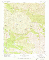
1969 Map of Santa Rita Peak
USGS Topo · Published 1973About this map
The high-elevation drainage divide of the San Benito Co Fresno Co line defines this area, where mining activity once pulsed through the canyons. Industrial history is etched into the landscape at Holman Mill (Site) and Joaquin Mill (Site), marking the locations of former processing operations. Numerous mining prospects like the James Corbett Byles Mine and Del Mexico Mine are clustered near Santa Rita Peak and along the slopes of Joaquin Ridge. Water sources were critical in this arid terrain, with Spanish Lake, Aqua Buena Spring, and Dick Wright Spring providing vital points for both livestock and mining camps. Remote encampments such as Archer Camp and the level ground at Adobe Flat suggest the logistical challenges of extraction and ranching in these uplands during the late 1960s.
Find a feature on this map
43 named features on this map. Tap any name to fly to it.
Don’t see what you’re looking for? This feature index may not catch every label — zoom into the map to look around manually.
Map Details
Editions of this 1969 Santa Rita Peak Map
2 editions found
Other maps of this area

1912 · Coalinga
USGS Topo · 1:125,000

1915 · Priest Valley
USGS Topo · 1:125,000

1941 · Priest Valley
USGS Topo · 1:62,500

1943 · New Idria
USGS Topo · 1:62,500

1943 · Joaquin Rocks
USGS Topo · 1:62,500
1944 · Coalinga
USGS Topo · 1:62,500

1944 · Priest Valley
USGS Topo · 1:62,500

1948 · Santa Cruz
USGS Topo · 1:250,000

1955 · Santa Cruz
USGS Topo · 1:250,000
1956 · New Idria
USGS Topo · 1:62,500