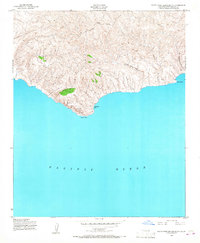
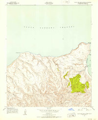
1943 Map of Santa Rosa Island South
USGS Topo · Published 1968About this map
Johnsons Lee sits on the southern shoreline of Santa Rosa Island, providing a rare named anchorage along this deeply incised coastal landscape. Mapped by Fairchild Aerial Surveys, Inc. for the Army Map Service during the Second World War, the topography is defined by sharp, parallel drainages like Jolla Vieja Canyon, Wreck Canyon, and San Augustin Canyon that cut through the high interior ridges toward the Pacific Ocean. This 1943 survey captures the island primarily as a land of survey markers and topographic extremes, including named peaks such as Soledad, Barton 2, and Grouse 2. The lack of inland development at this date reflects the island's isolation, with the coastal landmarks of South Point and Ford Point serving as the primary navigational aids for the maritime traffic of the Santa Barbara Channel.
Find a feature on this map
12 named features on this map. Tap any name to fly to it.
Don’t see what you’re looking for? This feature index may not catch every label — zoom into the map to look around manually.
Map Details
Editions of this 1943 Santa Rosa Island South Map
2 editions found
Other maps of this area
1943 · Santa Rosa Island East
USGS Topo · 1:24,000
1943 · Santa Rosa Island South
USGS Topo · 1:24,000
1943 · Santa Rosa Island West
USGS Topo · 1:24,000
1943 · Santa Rosa Island North
USGS Topo · 1:24,000

1948 · Santa Maria
USGS Topo · 1:250,000

1956 · Santa Maria
USGS Topo · 1:250,000

1957 · Santa Maria
USGS Topo · 1:250,000

1958 · Santa Maria
USGS Topo · 1:250,000

1962 · Santa Maria
USGS Topo · 1:250,000
1993 · Santa Rosa Island
USGS Topo · 1:100,000