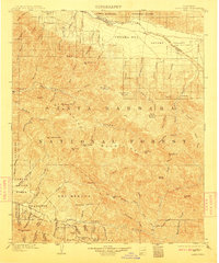
1905 Map of Santa Ynez
USGS Topo · Published 1911About this map
San Rafael Mountains and the rugged interior of the Santa Barbara National Forest dominate this early twentieth-century landscape. The map captures a transition between the northern Cuyama Valley, where the settlement of Wasioja sits near the Cuyama River, and the southern coastal range. Several Mexican land grant boundaries remain visible, including San Marcos, Tequepis, and Cañada de los Pinos, reflecting the area's deep pastoral roots. Higher elevations are marked by seasonal grazing lands known as potreros, such as Montgomery Potrero and Salisbury Potrero. In the south, the Santa Ynez Mountains rise above the Santa Ynez River, featuring the historic San Marcos Pass and the Painted Cave site. This survey illustrates the intricate drainage network of the Sisquoc River and numerous canyons before modern infrastructure altered the regional water and transit patterns.
Find a feature on this map
89 named features on this map. Tap any name to fly to it.
Don’t see what you’re looking for? This feature index may not catch every label — zoom into the map to look around manually.
Map Details
Editions of this 1905 Santa Ynez Map
5 editions found
Other maps of this area

1902 · Santa Ynez
USGS Topo · 1:125,000

1903 · Mt. Pinos
USGS Topo · 1:125,000

1904 · Ventura
USGS Topo · 1:62,500

1905 · Santa Ynez
USGS Topo · 1:125,000

1905 · Lompoc
USGS Topo · 1:125,000

1910 · Buena Vista Lake
USGS Topo · 1:125,000

1912 · McKittrick
USGS Topo · 1:125,000

1912 · Buena Vista Lake
USGS Topo · 1:125,000

1937 · Branch Mtn
USGS Topo · 1:48,000

1941 · Ventura
USGS Topo · 1:62,500