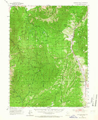
1952 Map of Santaquin Peak
USGS Topo · Published 1966About this map
Loafer Mountain and Santaquin Peak dominate this high-altitude landscape where the borders of Utah, Juab, and Sanpete counties converge. The 1952 field check documents a rugged transition between the Uinta National Forest and the Manti-La Sal National Forest. While much of the terrain is defined by dramatic relief like Black Canyon Creek and the Devils Kitchen formation, the human footprint is concentrated along the eastern corridor. Here, the Denver and Rio Grande Western railroad and U.S. 89 connect small settlements such as Birdseye and Indianola. Recreational and administrative development is evident through the Payson Guard Station, the Bear Canyon Recreation Area, and The Pines Campground, reflecting the mid-century management of these mountain ranges for both timber and public use.
Find a feature on this map
83 named features on this map. Tap any name to fly to it.
Don’t see what you’re looking for? This feature index may not catch every label — zoom into the map to look around manually.
Map Details
Editions of this 1952 Santaquin Peak Map
3 editions found

Other maps of this area

1885 · Salt Lake
USGS Topo · 1:250,000

1885 · Manti
USGS Topo · 1:250,000

1895 · Manti
USGS Topo · 1:250,000

1907 · Strawberry Valley
USGS Topo · 1:125,000

1909 · Strawberry Valley
USGS Topo · 1:125,000

1948 · Spanish Fork
USGS Topo · 1:24,000

1949 · Provo
USGS Topo · 1:62,500

1949 · Spanish Fork Peak
USGS Topo · 1:24,000

1950 · Spanish Fork
USGS Topo · 1:24,000

1950 · West Mountain
USGS Topo · 1:24,000